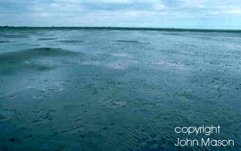
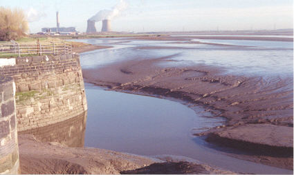
MUDFLATS
LOCAL BIODIVERSITY ACTION PLAN
 Links to associated SAPs
None
Current Status
The UK BAP defines mudflats as "sedimentary intertidal habitats created by deposition in low energy coastal environments, particularly estuaries and other sheltered areas". As a general rule the precise composition of the sediments is dependent upon wave energy leading to a transition from fine silts in the upper estuaries to coarser sediments with a higher proportion of sand towards the estuary mouth. The sediments generally consist of silts and clays with a high organic content. The JNCC Marine Nature Conservation Review (MNCR) biotope codes for mudflats are LMU.SMu (sandy mud shores) and LMU.Mu (soft mud shores) and LMS.MS (muddy sand shores).
Physical processes, eg erosion and deposition, intimately link mudflats and other coastal habitats such as saltmarshes and maritime cliffs. Mudflats frequently occur as part of the natural sequence of habitats between the sub-littoral zone and vegetated saltmarshes. Like most other intertidal areas they dissipate wave energy and thus have an important role to play in reducing the risk of erosion damage to saltmarshes and coastal defences, and of tidal flooding in low-lying coastal areas. In addition the mud (and the microbial and macroinvertebrate fauna associated with it) plays an important roll in nutrient cycling. In areas subjected to pollution organic material in the sediments can bind to pollutants and, as a result, the muds may contain elevated concentrations of heavy metals and other contaminants.
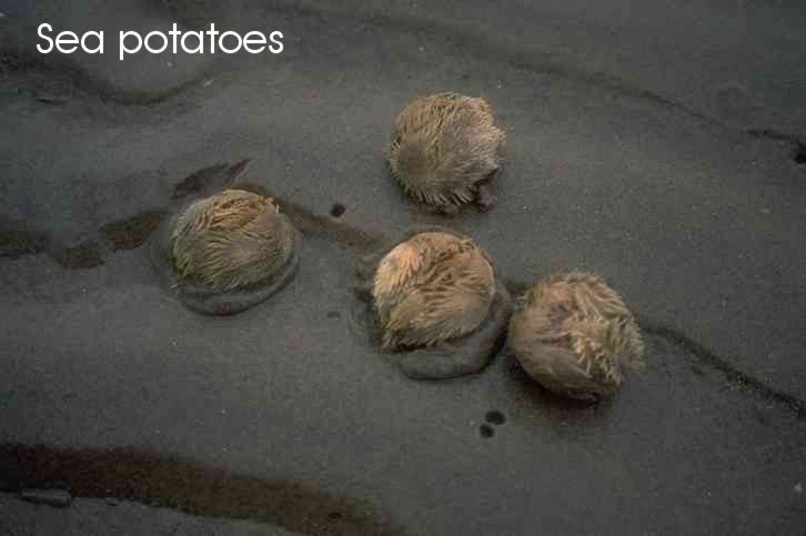
Mudflats are typically highly productive habitats supporting a high biomass but relatively low species diversity with few rare species. The precise nature of the biota reflects both the prevalent physico-chemical conditions and the degree of enrichment by, for example, sewage pollution. Generally speaking, in areas of lowered salinity, eg estuaries, the macroinvertebrate fauna will typically be of the Petersen Macoma community. Characteristic species are common cockle (Cerastoderma edule), laver spire shell (Hydrobia ulvae), ragworm (Hediste diversicolor) and the gammarid Corophium voluator. In conditions of very low salinity, eg upper estuaries, there may be large numbers of Oligochaetes, mainly Tubificoides spp. In coarser, ie more sandy, sediments the Polychaets Nephtys hombergi and Arenicola marina occur, and where the sediments are very coarse beds of sea-grass (Zostera spp) can develop. Where the sediments are artificially enriched, eg by sewage pollution, increased microbial activity can significantly reduce their oxygen content leading to stress in the animals living in them. As the level of enrichment increases animals are lost from the biota sequentially beginning with the larger, deep burrowing species and then smaller Polychaets and Bivalves. In badly polluted areas only worms such as Capitella sp, Scololepis sp and Tubificoides sp may remain, and in extreme cases there may be no macroinvertebrate fauna at all. Beds of common mussel (Mytilus edulis) or fucoid macroalgae may be present if there are stones or shells to act as attachment points.
The surface of the sediments may appear devoid of vegetation however they are often covered with dense mats of microalgae such as diatoms and euglenoids. These may make a significant contribution to the stability of the sediments as the mucilage that they produce helps to bind particles together. Under eutrophic conditions an extensive cover of the macroalgae Enteromorpha sp or Ulva sp may develop.
The total area of estuarine habitat in the UK is in the order of 588,000ha representing approximately 15% of the north-west European total. Of this just over half is intertidal habitat (sand and mud flats with a lesser amount of saltmarsh). Intertidal flats in the UK cover an area of approximately 270,000ha.
Mudflats are very important habitats that support huge numbers of birds and fish. They provide both feeding and resting areas for internationally important populations of waders and waterfowl and also act as nursery areas for flatfish.
Both the Mersey and Dee estuaries and the North Wirral foreshore feature significant areas of intertidal sand and mud flats. These are of very high nature conservation importance as feeding and resting areas for migrant and overwintering wildfowl and waders. This is reflected by the large number of proposed and designated nature conservation sites around the Wirral coast including the Mersey Narrows, Mersey Estuary, New Ferry, North Wirral Foreshore and Dee Estuary SSSI's, the Mersey and Dee Estuary SPA's and the Dee and North Wirral Foreshore cSAC's. There are also a number of locally designated Sites of Biological Importance (SBI's). Both the Dee and Mersey Estuaries are designated as wetlands of international importance under the Ramsar Convention.
The main importance of the mudflats to wildfowl and waders derives from their high productivity and consequent high biomass of prey items. They are also important as resting areas, a function that is enhanced by their relative inaccessibility and freedom from disturbance.
Protection for mudflats is provided by a variety of international agreements and EU legislation, implemented in the UK by the relevant enabling legislation. Further protection is afforded by UK domestic legislation. This takes the form of both direct protection for the habitat and indirect protection, eg by controls on factors affecting water quality.
International and European designations relevant to the Wirral coastline are the Ramsar Convention, the Birds Directive (Council Directive 79/409/EEC) and the Habitats Directive (Council Directive 92/43/EEC). Under the Habitats Directive SAC's may be designated for the Annex 1 habitat "Mudflats and sandflats not covered by seawater at low tide". Mudflats are also included in a number of other Annex 1 habitats such as "Estuaries", "Lagoons" and "Large shallow inlets and bays".
The Habitats Directive is transposed into UK domestic legislation by the Conservation (Natural Habitats &c) Regulations 1994. Under these regulations any activity with the potential to affect an SPA or SAC requires an Appropriate Assessment to be carried out by a Competent Authority.
In addition to protection under EU legislation over 300 estuarine SSSI's featuring mudflats have been designated nationally under the Wildlife and Countryside Act 1981. These include both the Mersey and Dee estuaries.
The water quality on mudflats (and other coastal habitats) should be improved through the application of a number of EU directives. Notable among these are the Dangerous Substances, Shellfish (waters), Bathing Waters, Integrated Pollution Control, Urban Waste Water Treatment and Water Framework Directives. The Oslo and Paris (OSPAR) Convention and North Sea Conference Declaration are also significant as these provide for the regulation of discharges to the sea and incorporate targets and quality standards covering a range of pesticides, metals and other toxic, persistent and bioaccumulative substances.
 Threats
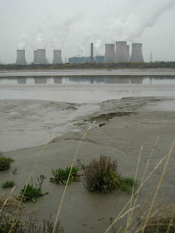
- Sea Level Rise - It is estimated that 8 - 10,000 ha of intertidal flats will be lost to sea level rise in England between 1993 and 2013. Sea level rise is due to a combination of postglacial sinking of the landmass and global warming. The net effect is that the low water mark moves landward while coastal defences prevent a compensating landward migration of the high water mark leading to the phenomenon of 'coastal squeeze'. This factor may have a very serious impact in the future, particularly on the Mersey Estuary and North Wirral coast. Both of these areas are heavily constrained by coastal defences and have limited or negligible potential for managed retreat. Any landward migration of the low water line resulting from sea level rise will therefore result in problems of coastal squeeze.
- Land Claim For Development - Approximately 25% of British estuarine intertidal flats have been lost to urban, transport infrastructure and industrial development (with up to 80% loss in some estuaries). The loss of intertidal flats can have a profound effect on estuarine productivity and may also impact on other estuarine habitats, eg saltmarsh. Although the rate of loss has slowed considerably in recent years it has not stopped.
- Barrage Schemes - Schemes for water storage, amenity, tidal power and flood defence continue to pose a threat to intertidal flats and other estuarine habitats.
- Polluting Discharges: Discharges from agriculture, industry and urban areas can lead to the formation of abiotic areas or algal mats which may have a profound impact on invertebrate communities (and indirectly on the communities of birds, fish etc which feed on them). The loss of embedded fauna can lead to destabilisation of the sediments making them vulnerable to erosion.
- Oil And Gas Exploration - Many coastal and estuarine areas are now licensed for oil and gas exploration and development. These activities can have a serious impact on the sediment biota, and also on sediment supply and transport.
- Fishing And Bait Digging - These activities can have a serious adverse impact on both the community structure and substratum of intertidal flats. For example, suction dredging for shellfish or the juvenile flatfish bycatch from shrimp fisheries may alter predator - prey relationships.
- Human Disturbance - The presence of humans and many human activities can impact on the use of intertidal flats by feeding and roosting birds.
- Alien Species - The introduction of novel or non-native species, such as the cord grass Spartina anglica, can have a profound effect on the nature of intertidal flats leading, for example, to the development of pioneer saltmarsh at the expense of the mudflats. While pioneer saltmarsh may not be without its ecological value the overall change in the balance of habitats present may make the area as a whole less attractive to wildlife.
- Changed Estuarine Dynamics - Hydrodynamic changes within estuaries and coastal regions will inevitably lead to changes in the pattern of erosion and deposition of fine sediments. Sea level rise and increased storm frequency resulting from climate change may further influence this effect.
- Shipping (and in particular the need to maintain shipping channels by dredging).
- Local changes to water movement and sediment transport are a particular threat as there are numerous developments both within and outside the Wirral that have the potential to change these fundamental processes. Examples include coastal defence schemes, navigational dredging (and dredge spoil disposal) and increased shipping.
- Eutrophication poses a significant threat for both the Dee and Mersey Estuaries. Serious eutrophication can potentially damage mudflats and other intertidal habitats through smothering and by de-oxygenation, eg shellfish kills as a result of Phaeocystis bloom crashes have occurred in the area.
- Many members of the local community perceive natural habitat change to be a threat. In order to overcome this perception and manage habitat changes, such as the development of saltmarsh on areas that were previously sand or mudflat, Local Authorities and other landowners will need to be able to promote natural change with a minimum of human intervention.
How are we helping to conserve Mudflats in the Cheshire region?
- Government departments, such as DEFRA, have a responsibility to assess the potential impacts of operations which may affect intertidal habitats, eg oil and gas production, aggregate extraction, land reclamation, marine construction and the dumping of dredged materials, prior to licensing. Licenses may be refused on environmental grounds or may include conditions to limit the environmental impact.
- The statutory nature conservation agencies have included the management of intertidal habitats within a number of wider plans. The Environment Agency, Local Authorities, National Assembly for Wales and Scottish Natural Heritage all collaborate on the development of Shoreline Management Plans (SMP's). While the main remit of these is for coastal and flood defence they also recognise the importance of mudflats and other intertidal habitats. In addition, Scottish Natural Heritage leads the Firths Initiative. The UK Marine SAC project is an EU LIFE funded programme with a remit to develop management plans for implementation under the Habitats Directive, and which includes mudflats. Intertidal habitats, including mudflats, are also covered by many Estuary Management Plans and by Local Environment Agency Plans (LEAPs). These habitats also benefit from inclusion in National, Local and other nature reserves. The Mersey Estuary Action Programme (MEAP) contains actions aimed at protecting and enhancing both the extent and quality of natural habitats, including mudflats and other intertidal habitats, within the Mersey Estuary. Similarly the Dee Estuary Strategy aims to improve natural habitats within the Dee Estuary through a co-ordinated plan of action and network of communication. Both the MEAP and the Dee Estuary Strategy act as a framework within which Local Authorities, government and other agencies and other organisations with an interest in either of the estuaries can act in a coherent manner in order to improve their quality.
- Recent or current research into mudflats includes the Natural Environment Research Council (NERC) special research topic Land Ocean Interaction Study (1994 - 98). This included estuarine and coastal processes with a component on littoral sediment processes. The ECOFLAT project, carried out under the EU Marine Science and Technology (MAST) programme, looked at mudflat physical/biological processes and interactions.
- English Nature have carried out studies of intertidal area loss in Essex and also a collaborative project with the Environment Agency looking at managed retreat as a flood defence option on the Blackwater Estuary. This project included studies of estuarine hydrodynamics, sediment erosion/accretion and the recreation of intertidal habitats, including mudflats.
- Planning guidelines, eg PPG20, NPPG7 and NPPG13, identify the consultation requirements for the development of wetland and coastal habitats and provide a legal framework for their consideration in the light of proposed developments.
- A large number of waste water treatment infra-structure improvements have been carried out recently which should significantly improve water quality, in both the Dee and Mersey Estuaries. This in turn should impact positively on the environmental quality of mudflats and other intertidal habitats. These improvements have come about as a result of a £500 million work programme driven by the Urban Waste Water Treatment Directive and mediated by the Asset Management Planning (AMP) process.
Objectives and Local Targets
The overriding objective is to maintain mudflats and other intertidal and subtidal habitats with which they interact in a favourable condition both in terms of their extent and distribution and their water/sediment quality. In pursuing this objective it is necessary to clearly identify and distinguish between on going natural change and that which is the result of human intervention, including landclaim and coastal squeeze, as it sets the overall framework for management action. The overall objective may be achieved by the following means:
| 1 |
Safeguard mudflats and other intertidal habitats from encroaching development by incorporating appropriate policies into Local Development Plans. |
| 2 |
Influence the planning process in such a way as to prevent or modify development which would be detrimental to mudflats and other intertidal habitats, or to secure adequate mitigation where this is not possible. |
| 3 |
Promote the use of managed retreat as a flood defences option where possible. |
| 4 |
Promote improvements in water and sediment quality by working to bring about further waste water treatment infrastructure improvements, eg through the AMP process, and by reducing other point and diffuse discharges both to coastal and inland waters. |
| 5 |
Work to reduce nutrient inputs to the coastal zone by promoting best practice and responsible management throughout the whole catchment, including inland, transitional and coastal waters. |
| 6 |
Educate the public, planning authorities and others as to the importance of intertidal habitats, particularly mudflats, which are often seen as unsightly or dangerous. There is a need to stress the importance of education via interpretation, such as the work of the various Countryside Management and Ranger services. More could be made of estuarine habitats by linking educational trips to visitor centres and the local coast to the curriculum. |
| 7 |
Improve knowledge of the ecological health of mudflats and other intertidal habitats around the Wirral coast by carrying out surveys and recording of key species, eg waders/wildfowl and invertebrates. |
| 8 |
Engage the general public in the conservation of mudflats and other intertidal habitats and attempt to create a sense of ownership by, for example, encouraging members of the public to submit records of wildlife sightings or by organising foreshore based events and activities. |
Actions Required
- Map the extent and distribution of mudflats and other intertidal habitats and their usage by key species such as birds and seals, eg as feeding or haul-out sites. In light of this knowledge consider extending existing designated sites or creating new ones.
- Prevent further loss of mudflats and other intertidal habitats by opposing development proposals that would result in either direct habitat loss through land-take or indirect habitat loss through changes in the pattern of erosion and accretion of sediments.
- Wirral's UDP already includes a policy that looks to safeguard the intertidal zone from development which would have an adverse effect on coastal and marine nature conservation interests. As part of the forthcoming UDP review, consider whether further policy protection against both the direct and indirect loss of mudflats and other intertidal habitats is needed.
- There is a perceived need for a new policy on the management of Spartina. At the present time ad hoc management decisions are taken by local authorities, landowners and managers, eg spraying and mechanical removal. As Spartina and saltmarsh development directly affect the area and quality of mudflat it follows that there is a need for a management plan that can inform these decisions. This needs to operate on an estuary wide basis because the precise action that a Local Authority or other landowner takes will depend on the estuary wide status of Spartina and other pioneer saltmarsh species. Furthermore, a decision needs to be taken as to whether this species is seen as alien and invasive or as a semi-natural plant that may provide a mechanism to cope with predicted increases in sea level.
- Promote best practice, for example in the use of fertilisers, in the inland catchments in order to reduce nutrient loads in coastal and estuarine waters.
- Promote the use of managed retreat as a flood defence option where possible (although it is accepted that there is limited scope for this, particularly along the Mersey and North Wirral shores).
- Educate the public, planning authorities and others as to the importance of intertidal habitats, particularly mudflats, which are often regarded as unsightly or dangerous. This could be achieved by, for example, the use of interpretative material in visitor centres and other areas where the public have access to the foreshore.
- Collect and collate baseline biological, fisheries and water/sediment quality data for the Wirral coast and the Mersey and Dee Estuaries. Ensure that this data is made available to all that require it in a form that will be easily accessible to the general public.
- Seek to establish a routine biological, fisheries and water/sediment quality monitoring programme for the Wirral coast and Mersey/Dee Estuaries and ensure that the data is made available to all those who require it. Monitoring should be based on rigorous scientific principals with clearly defined objectives.
- Seek to initiate a research project aimed at defining the overall sediment budget for the Mersey and Dee estuaries. This knowledge will be necessary in order to place changes in the distribution of mudflats within the HAP area into a sensible context.
- Ensure data sharing between all organisations involved in coastal zone management.
- Raise public awareness of the implications for biodiversity of activities that impact on the quantity and quality of mudflats and other intertidal habitats.
Progress so far
How to find out more about Mudflats
This plan is part of the Wirral Biodiversity Action Plan which can be viewed at www.wirral.gov.uk/ed/biodiversity/home.htm
UK BAP for Mudflats - www.ukbap.org.uk/UKPlans.aspx?ID=34
Contact details
| LBAP Chair |
Andy Goodwin, Environment Agency,
Phone: 01925 840000 |
| National Lead Partner |
Environment Agency |
| National Contact |
Duncan Huggett, Environment Agency
Phone: 01491 828545
|
References & Glossary
HMSO (1995): Biodiversity: The UK Steering Group Report, Volume 1: Meeting the Rio Challenge, London.
HMSO (1995): Biodiversity: The UK Steering Group Report, Volume 2:Action Plans, London.