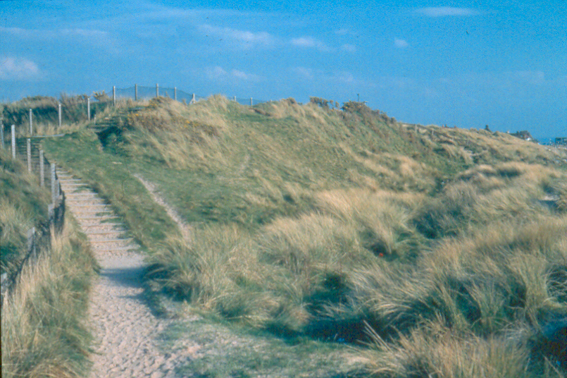
COASTAL SAND DUNE
LOCAL BIODIVERSITY ACTION PLAN
 Links to associated SAPs
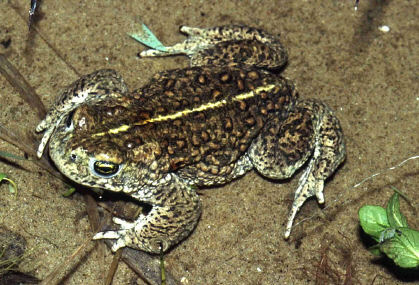
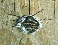
Natterjack Toad, Belted Beauty Moth
Current Status
Nationally sand dune habitat is seen as 'Unfavourable with some improvements' - The total area of sand dune in the UK is recorded as 54,500 ha. European - 'Unfavourable declining' - Sand dunes are a declining and threatened habitat throughout Europe.
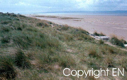
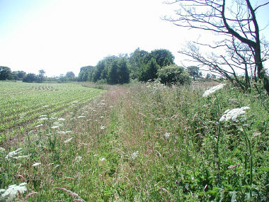
The sand dune habitats in Wirral cover approximately 80 ha. (approx. 0.15 % of UK area) this represents all of Cheshire's sand dune resource.
The main areas of sand dune habitat are:
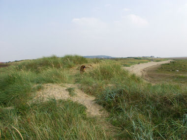
- West Kirby Dunes (Red Rocks/Royal Liverpool Golf Club) (7 Ha & 30(60-30) ha)
- Meols Dunes ( approx 6 ha)
- Leasowe and Wallasey Dunes ( 9 ha & 3 ha + 25(55-30) ha)
- There are in addition a number of very small patches on former dunes in the Hoylake and Meols area (approx. <1 ha) (the sand dune areas estimated for the golf courses are total area minus 30 ha for greens and fairways).
The following notifications give legal protection for a very small proportion of the sand dune habitats
- Dee Estuary Ramsar
- Dee Estuary cSAC
- Dee Estuary SSSI
- Red Rocks SSSI
- North Wirral Foreshore SSSI
Three other areas containing the vast majority of the sand dune habitat are designated as SBIs. This confers a very limited degree of protection, through the planning process. The SBI's are:
- Royal Liverpool Golf Course
- Leasowe Common
- Leasowe Dunes and Wallasey Golf Course
Threats
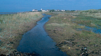
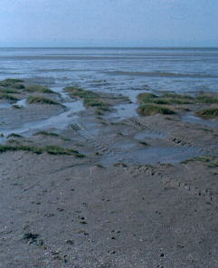
- Erosion & Accretion - The dunes at West Kirby are advancing slowly due to the build up of sand on the beach. This has resulted in a low embryo dune ridge, with saltmarsh and dune slack habitats behind. The dunes at Meols and Leasowe/Wallasey are anchored behind the sea wall and are so are cut off from a fresh sand supply. There is a very small developing dune system in Leasowe Bay, seaward of the main coastal defences, but protected by inshore breakwaters. The vegetation developing on Hoylake beach (due to Beach level rise from windblown sand) is currently of the salt-marsh type; however predictions indicate that areas of sand dune habitat will develop within this as happened at West Kirby in the 1990's.
- Falling Water Levels - The regime of pumping drainage water from the Royal Liverpool Golf Course has a significant impact on the Dune slacks at West Kirby, especially the breeding success of the Natterjack Toad population. The significance of this issue however, is not widely agreed.
- Grazing - No grazing, either by livestock or rabbits takes place.
- Recreation - An estimated 70% of present sand dune habitat lies within the courses. Although the nature conservation interest of Wallasey and Royal Liverpool golf courses is kept quite high due to sensitive management of large areas of rough, recognised in their status as SBIs, the management of these sites as golf courses has necessarily resulted in depreciation from their potential value. The Leasowe Golf Course being smaller (approx. 30 ha) has little area of rough, and has therefore no significant sand dune habitat. Heavy public use of the West Kirby frontal dunes, Meols and the Leasowe dunes has resulted in large amounts of erosion. Although presently not as severe as in the past it is still a major problem.
- Coastal Defences - The extension of the West Kirby Marine Lake (1986/7) has resulted in increased deposition of sediments in front of the West Kirby dunes. The coastal defences in the Meols Moreton and Leasowe area were first built in 1794 to replace the rapidly eroding sand dunes. They have had the effect of cutting off the sand supply from the beach. The existing sand dunes are now threatened by this lack of sand supply, whereas the former Moreton sand dunes have completely disappeared. The breakwaters in Leasowe Bay have resulted in the accumulation of sediment, and new dunes are forming at the eastern (downwind) extremity.
- Beach Management - Mechanical beach cleaning takes place at West Kirby, Hoylake, Leasowe Bay, Wallasey and New Brighton. This removes much of the strandline and many seedlings in particular of Puccinelia maritima, and so retards or prevents natural succession. There is also regular digging and ploughing of salt-marsh vegetation at Hoylake, which likewise prevents succession. Public access by vehicle is not allowed although occasionally occurs.
- Tree Planting - Much dune management prior to 1989 consisted of planting trees to stabilise the dunes. This was most widespread in the Leasowe dunes, where unfortunately Hybrid Poplar and Elm became established. West Kirby and Meols dunes are relatively free of trees.
- Development - Much of Hoylake, Meols and parts of West Kirby and Wallasey are built on former sand dunes, an estimated 400ha (5 times the present area) has probably been lost to development. This is difficult to estimate because of the inaccuracy of old maps.
- Tipping - The largest area to suffer from this is Leasowe Bay. Inert hardcore was dumped here until 1978. Together with sand extraction from the dunes by Leasowe Golf Club, approximately 3 ha of sand dunes have been lost due to these schemes. Small scale tipping of sand collected from beaches has taken place in West Kirby and Leasowe dunes.
- Sand Extraction - The largest area to suffer from this was on Leasowe Golf Course, see above. There is an issue of potential sand extraction in NW Wirral, which although uneconomic, may happen due to public inability to accept the vegetation of the beaches.
- Nutrient Enrichment - The heavy use of the dunes and upper beaches by dog walkers could potentially lead to development of non-dune vegetation due to enrichment from dog faeces. The leaf-litter from planted trees within the dunes causes eutrophication, and has led to a loss of dune vegetation in the vicinity.
The use of wood chippings to surface paths in Leasowe dunes has led to minor changes in path-side vegetation. The significance of aerial deposition of nitrogen is not known.
- Mowing & Scarification - This takes place mostly on the golf course sites. Its significance for wildlife is both disadvantageous and advantageous, depending upon the exact regime. Small experimental plots have been mown/strimmed at Meols in an attempt to increase the population of Belted Beauty Moth.
- Introduced Species - Stabilisation work in the past resulted in the planting of Hybrid Poplar and Elm trees becoming established.
- Sea Level Rise - The rising beach levels are predicted to keep up with or outpace sea level rise. [Wirral Dee Study, 1990]
How are we helping to conserve Coastal Sand Dunes in the Cheshire region?
- The beaches are owned and managed by Wirral Council within the constraints of English Nature and the SSSI /cSAC legislation.
- The maintenance of the current legal status of some of these sites outlined above does help prevent further damage.
- Wirral Ranger Service manages the Meols and Leasowe dunes within the boundaries of the North Wirral Coastal Park.
- Strand-lines adjacent to the embryo dunes at West Kirby are not removed by the beach cleaning operation.
- Footpaths at Leasowe and West Kirby are managed by signing and surfacing to reduce erosion.
- Blowouts are fenced, either as exclosure plots (Leasowe) of with sand-trap fencing (Meols and West Kirby)
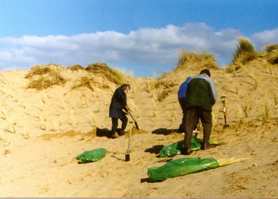
- Marram planting takes place in exclosure plots at Leasowe.
- Tree and scrub vegetation is reduced to a minimum.
- Areas of 'rough' on golf courses are left almost unmanaged although light occasional mowing takes place adjacent to fairways.
- A database of species is kept on the North Wirral Coastal Park by Wirral Ranger Service.
- Regular surveys are undertaken on the SSSI and SBI dunes by Cheshire Wildlife Trust.
- Interpretation through on site Rangers, notice boards and guided walks, and liaison with organisations of site users are important at promoting the importance of the sites.
Objectives, Targets and Actions
OBJECTIVES |
LOCAL TARGETS |
1. Protect the existing resource of sand dune habitat from loss in area or degradation in quality.
2. Improve the quality of existing sand dune habitat towards favourable conservation status. |
1.Continue and expand annual recording of beach and dune profiles.
2. Carry out an NVC survey of all dune habitats by 2005 |
ACTIONS REQUIRED |
- Designate the North Wirral Coastal Park, with its sand dunes of Meols and Leasowe as a Local Nature Reserve by end of 2003.
- Identify funds for NVC surveys by end of 2003.
- Seek to have designated additional sand dune sites under SSSI legislation. In particular Meols and Leasowe sand dunes by end 2005. This will involve having a full NVC survey of the sites by end of 2003.
- Through the Shoreline Management Plan and Beach Management groups, develop policies that allow for the natural succession to sand dunes in areas away from the main amenity beaches by end of 2003.
- Wirral's UDP already safeguards those areas of sand dune which carry nature conservation designations from the direct impact of development. As part of the forthcoming UDP review, in 2004 consider the scope for including a policy/policies looking to control the impact of land uses which may have an indirect effect on dunes, for example new stables and riding facilities which may have access onto the North Wirral Coast.
- Investigate ways to restrict the expansion in horse riding in the sand-dunes due to its severe erosion effects. This is especially bad at Meols Dunes.
- Identify new works to benefit existing dunes.
- Work with the three Golf clubs to manage their courses in a way that benefits their nature conservation value, possibly through national golf organisations.
- Prevent interference with natural forces creating new area of sand dune, except where these cause a safety hazard to the public, Eg. The Highway, or severe economic hardship.
- Improve signage, way-marking and interpretation
- Construct paths where signage cannot reduce erosion resulting from recreational pressure and there is no alternative path to way-mark. The traditional boardwalk will probably not be the most practicable or cost effective option and unbound surfaced paths may need to be used, although access to those with special mobility needs must be considered.
- Discuss management of rough grassland under golf course management with appropriate local and national managers so as to benefit their nature conservation value.
- Establish the sources of dune enrichment by 2005, in order to see if any can be reduced, Eg. What is the significance of dog faeces?
|
Progress so far
| 2005 Action Completed |
- Four interpretive boards were erected in Wallasey Dunes.
- Three interpretive boards were erected in Meols aimed at educating horse riders.
- The bridleway from Leasowe to Meols was up-graded.
- Chestnut paling was used extensively in the dunes to restict horse access.
- An NVC survey of the North Wirral Coastal Park was completed.
- Marram grass from the Sefton Coast was planted in Wallasey dunes to repair serious blow-outs.
|
How to find out more about Coastal Sand Dunes
This plan is part of the Wirral Biodiversity Action Plan which can be viewed at www.wirral.gov.uk/ed/biodiversity/home.htm
UK BAP for Coastal Sand Dunes - www.ukbap.org.uk/UKPlans.aspx?ID=28
Contact details
| LBAP Chair |
Christine Smyth, Wirral MBC
0151 637 6206 |
| National Lead Partners |
Scottish Natural Heritage
|
| National Contact |
Stewart Angus, Scottish Natural Heritage
Phone: 01463 712221 |
References & Glossary
HMSO (1995): Biodiversity: The UK Steering Group Report, Volume 2: Action Plans, London.
HMSO (1995): Biodiversity: The UK Steering Group Report, Volume 1: Meeting the Rio Challenge, London.
Wirral Dee Study, 1990, Borough Engineers, Metropolitan Borough of Wirral.
Liverpool Bay Shoreline Management Plan, 1998, Borough Engineers, Metropolitan Borough of Wirral.
North West Regional Planning Guidance S/11/298/APP3 (North West Biodiversity Targets)